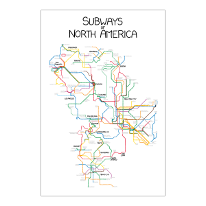
 Great “Subways of North America” map from xkcd, connects the rapid transit lines of Miami, Atlanta, Washington, Baltimore, Philadelphia, New York City, Boston, Cleveland, Los Angeles, San Francisco, Toronto, Vancouver, Montreal, Mexico City, San Juan, Santo Domingo, and Monterrey. Inclusion of Cleveland means a “subway” doesn’t really have to be underground for more than a few yards, and exclusion of Pittsburgh means that light rail doesn’t count (unless it’s connected to rapid transit as in Philadelphia). Special features include the Trolley Route 10 from Philadelphia to Los Angeles, connecting to the Ohio-California Tunnel.
You can even buy it as a poster for $15. Looks like you have to use Google or Paypal, however.